News and Notices
Brief Introduction
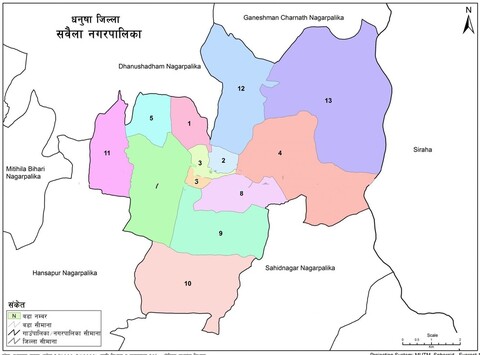
Pursuant to the Constitution of Nepal (2015), the High-Level Commission formed for the restructuring of local levels of the Government of Nepal submitted its report to the Government of Nepal on January 6, 2017. As per the decision of the Government of Nepal to implement local levels from February 9, 2017, Sabaila Municipality was formed by incorporating the nine former Village Development Committees (VDCs) of Paterwa, Sabaila, Manharwa, Thilla, Yaduwa, Satosar, Kharihani, Kajara Ramaul, and Raghunathpur, located in the southern part of the former Janakpur Zone under the Mid-Western Development Region. In accordance with the constitutional arrangement of adopting a federal governance system, Sabaila Municipality lies in the northeastern part of Dhanusha District in Madhesh Province, which is divided into seven provinces. The office of Sabaila Municipality is located 17.8 km from Dhanusha Bazaar, the district headquarters of Dhanusha District. This municipality has 13 wards. Spanning an elevation of approximately 85 to 112 meters above sea level, the municipality has a total area of 64.47 square km. To the west of this municipality is Dhanushadham Municipality, to the north is Ganeshman Charnath Municipality, to the east is the Kamala River, and to the south is Shahidnagar Municipality. The municipality has 12,430 households and a total population of 62,282, of whom 30,082 are male and 32,200 are female.